Imnavait Creek Grid Landforms
- Imnavait Grid
- Vegetation
- Elevation
- Landforms
- Releve Locations
- Glacial Geology
- Percent Water
- Surficial Geology
- Surficial Geomorphology
| Available data: | ||||
 |
 GE |
 Metadata |
 GIS data |
 GIS data |
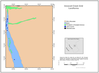
(from metadata) Elevation strongly influences temperature, soil moisture and patterns of tundra plant communities. Landforms were grouped into the following classes for map display:
- Hill or mountain: Includes undifferentiated hills and mountains of all slopes and sizes. Includes moraines and kames.
- Bluff or cliff: Very steep slopes usually associated with bedrock areas or eroded lake and river margins.
- Basin: Refers primarily to colluvial basins (Kreig and Reger 1985), between hills usually filled with wetlands and broad watertracks.
- Drained or filled lakes: Includes drained glacial kettle lakes in outwash deposits, drained glacial moraine-damned lakes such as the ancient Lake Galbraith, and filled lakes and pond margins.
- Floodplain or floodplain terrace: Includes active and nonactive floodplains and glaciofluvial outwash, ancient floodplains, also wide drainages filled with watertracks, abandoned sloughs, point bars, oxbows, etc.
- Alluvial fan: Includes nearly flat alluvial fans associated with existing and ancient lakes and steep alluvial fans at the base of steep valleys that are products of debris flows.
- Lake or pond.
- Disturbed area: Includes gravel mines and gravel construction pads.
 |
|
| The University of Alaska Fairbanks is an affirmative action/equal opportunity employer and educational institution. | |
|
Loading
| |
Last modified: January 17, 2012