Toolik-Arctic Geobotanical Atlas: Overview
The Toolik-Arctic Geobotanical Atlas (TAGA) is a web-based multi-scale collection of geobotanical maps (Walker DA 2002) and related material. It was developed as a research tool for scientists at the Toolik Field Station in northern Alaska. A wide variety of other users will also find the information valuable for general background and as an educational tool.
Select a name or map area to see a list of map themes.
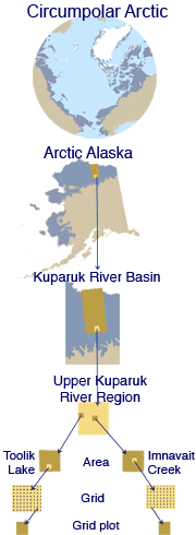
The TAGA is a synthesis of information and maps produced during 27 years of vegetation research in northern Alaska and the circumpolar Arctic. A concerted effort has been made to provide a common legend and color framework for maps made at eight different scales — from 1-m2 plots to the entire Arctic. It focuses on research plots, grids, and areas around the intensive research sites at the Toolik Field Station and Imnavait Creek, Alaska. Other map areas include the upper Kuparuk River region, the entire Kuparuk River watershed, Arctic Alaska, and the Circumpolar Arctic.
Diverse geobotanical themes for each map area include geology, topography, landforms, surficial geomorphology, soils, and vegetation, and various remote-sensing products. Maps of the vegetation plot locations are linked to photos and data from the plots.
The TAGA includes the following major sections
Maps
The maps are the heart of the TAGA. Maps can be found by first clicking on an area of interest from either the alphabetical list of areas included, or by reference to the hierarchy of areas. Once an area is selected then click on the desired theme. Each map is displayed with its legend.
Explanations and photos of the map units can be obtained by clicking on the unit name or color. These data include detailed explanations and photographs of representative examples of each map unit. There are also links to (1) photos of each plant species mentioned, (2) pdfs of key publications related to each map, (3) supporting vegetation, environmental, and soil data used in the vegetation classifications and analysis, and (4) definitions of geobotanical terms.
Icons at the bottom of each map allow the user to obtain a pdf copy of the map, download the GIS data file, or view the map in GoogleEarth.
Themes for the Arctic Alaska area.
Enlarge image
Photo Library:
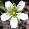 Minuartia obtusiloba |
The photo library contains all the graphics and photos of map units and plant species mentioned in the TAGA. The photo thumbnails are linked to enlargements and legends explaining the photos. Plant species photos are also linked to a wide variety of literature sources that contain detailed descriptions, distribution maps, and other useful information. |
Supporting Data:
 Drawn by John Adams, 1991. |
The background data was previously only available in data reports at the Alaska Geobotany Center or as pdf files available from the national data archives. This section currently contains information from two unpublished data reports in more digestible formats. Included are maps and photos of the study plots, and the original vegetation, environmental and soil data used in the vegetation classification and analysis (M.D. Walker et al. 1994). The data are presented in tables for each study plot and as downloadable Excel or Word files, and PDFs. |
Bibliography:
This section includes all references cited in the TAGA and a list of publications produced by the Alaska Geobotany Center.
Glossary:
Definitions of key terms used in the Atlas are here.
About the TAGA:
This section contains contact information, copyright information, credits, and a list of funding agencies and key collaborators. There is also a detailed site map.
The maps and web site were developed at the Alaska Geobotany Center in collaboration with several other groups at the University of Alaska Fairbanks (see About the TAGA).
 |
|
| The University of Alaska Fairbanks is an affirmative action/equal opportunity employer and educational institution. | |
|
Loading
| |
Last updated: October 30, 2023