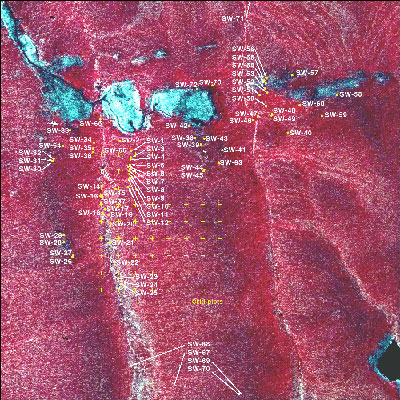
Imnavait Creek Area Releve Locations
- Imnavait Area
- Vegetation
- Elevation
- SPOT
- Landforms
- Releve Locations
- Glacial Geology
- Percent Water
- Surficial Geology
- Surficial Geomorphology
- Literature

| Available data: | ||||
| |
GE |
Metadata |
GIS data |
GIS data |
Appendix 4. Vegetation study plot locations (Walker et al. 1987)
This map shows the location of 73 study plots at the R4D research site near Toolik Lake, Alaska. The data collected from these plots are summarized in Permanent vegetation plots: Site factors, soil physical and chemical properties and plant species cover, in the Supporting Data section of the TAGA. The data report brings together for easy reference all the available plot data and supercedes earlier data reports (Walker et al. 1985). This information is being used in the classification and mapping of the vegetation and the analysis of the environmental controls (Walker et al. 1987). It provides useful input to several phases of the R4D research including the landscape ecology, slope modeling, and the primary productivity studies.
The field sampling was conducted during the periods of August 1-10, 1984 and August 17-September 4, 1985. During the same periods, field surveys were conducted for geobotanical mapping (Walker et al. 1987). Sixty-seven of the plots were permanently marked. Plots SW-67 through SW-71 were sampled during the mapping transects, but because they were remote from the intensive study site, were not permanently marked.
The sampling was done in representative examples of the major vegetation community types, particularly of the area within the main R4D watershed. Included in the data report are Tables 1 through 8, summarizing the collected data, and with links to a PDF and an MS Excel or MS Word file. There are also four appendices, with plot and soil photos, a sorted species table (not available online), a list of approximate equivalent vegetation units in other northern Alaskan and northwestern Canadian studies, and this plot location map.
- Table 1, List of vegetation communities and microsites sampled in 1984 and 1985.
- Table 2, Summary of areas sampled in 1984 and 1985.
- Table 3, Legend for the environmental variables used in the R4D vegetation studies.
- Table 4, Environmental variables for the R4D permanent vegetation plots.
- Table 5, Soil descriptions for representative vegetation communities.
- Table 6, Soil physical characteristics for the R4D permanent vegetation plots.
- Table 7, Soil chemical characteristics for the R4D permanent vegetation plots.
- Table 8, R4D permanent study plot vegetation data, species cover (percent), sorted by growth form.
Walker DA, Lederer ND, and Walker MD. 1987. Permanent vegetation plots: Site factors, soil physical and chemical properties and plant species cover. Department of Energy R4D Program, Institute of Arctic and Alpine Research, University of Colorado, Boulder, CO.


