Circumpolar Arctic About the vegetation map units
- CAVM
- Vegetation
- About the Vegetation Map Units
- Bioclimate Subzones
- Floristic Provinces
- AVHRR
- Elevation
- Lake Cover
- Physiography
- NDVI and Phytomass
- Substrate Chemistry
- Coastline
- Literature
- Hierarchy of Geobotanical Vegetation Map Units (Walker DA 2002)
| Available data: | ||||
 |
 GE |
 Metadata |
 GIS data |
 GIS data |
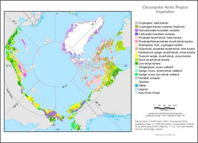
Mapped polygons at 1:7.5 million scale contain many vegetation types. The map often portrays the dominant zonal vegetation within each mapped polygon. Zonal sites are areas where the vegetation develops under the prevailing climate, uninfluenced by extremes of soil moisture, snow, soil chemistry, or disturbance, and are generally flat or gently sloping, moderately drained sites, with fine-grained soils (Vysotsky 1927). Large areas of azonal vegetation that are dependent on specific soil or hydrological conditions, such as mountain ranges and large wetlands, were also mapped.
The legend contains five broad physiognomic categories:
- B — barrens
- G — graminoid-dominated tundras
- P — prostrate-shrub-dominated tundras
- S — erect-shrub-dominated tundras
- W — wetlands
These are subdivided into 15 vegetation mapping units with numeric codes added to the alphabetic codes. The mapping units are named according to dominant plant functional types except in the mountains where complexes of vegetation are named according to the dominant bedrock (carbonate and noncarbonate mountain complexes). The coloring scheme of the map is suggestive of the physiognomy of the vegetation. The plant functional types are based on a variety of criteria including growth form (e.g., graminoids, shrubs), size (e.g., dwarf and low shrubs), and taxonomical status (e.g., sedges, rushes, grasses). The legend takes into special consideration the stature of woody shrubs, which is a major diagnostic feature of zonal vegetation in the Arctic (Edlund and Alt 1989, Walker et al. 2002, Yurtsev 1994).
Very steep bioclimate gradients occur in mountains, so these areas are mapped as complexes of elevation belts. Mountainous areas of the map are shown with hachures; the background color indicates the nature of the bedrock, and the color of the hachures indicate the bioclimate subzone at the base of the mountains.
 |
|
| The University of Alaska Fairbanks is an affirmative action/equal opportunity employer and educational institution. | |
|
Loading
| |
Last modified: October 25, 2012