Kuparuk River Region/Toolik Lake

Vegetation in the vicinity of the Toolik Field Station, Alaska. 2008, Side 1.

Vegetation in the vicinity of the Toolik Field Station, Alaska. 2008, Side 2.
In progress, will be added in 2009.
About the Toolik Atlas
Select image to enlarge
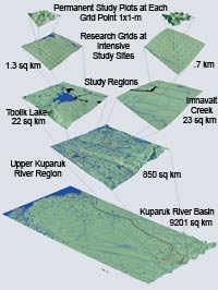
The Toolik Lake/Kuparuk River Basin Hierarchic Geobotanical Atlas was constructed over the course of several funded projects centering on the Imnavait Creek/Toolik Lake areas of the Upper Kuparuk River region. The TLKGA, when combined with CAVM and the AATVM, is a unique resource that spans spatial scales from individual plants to the circumpolar region. The Atlas has a unified system of scales, map legends, map colors, and methodology that makes them particularly useful in efforts to scale plot-based research to regional and circumpolar scales. A wide variety of supplementary information is also in the Atlas, including links to key data sets, photographs, and publications.
Suggested Citation:
Walker, D.A. and H.A. Maier. 2008. Vegetation in the Vicinity of the Toolik Field Station, Alaska. Biological Papers of the University of Alaska, No. 28. Institute of Arctic Biology, Fairbanks, AK.
Purchase the Map:
Contact Marie Gilbert at the Institute of Arctic Biology (907.474.7412), on the University of Alaska Fairbanks campus. Map is printed on glossy paper; available in an envelope or rolled with a rubber band for $10.00, or in a mailing tube for $13.50. Price list for Biological Papers of the University of Alaska (BPUA) (PDF, 43K)
Maps
The Toolik Atlas consists of maps of the Arctic Slope, Kuparuk River Basin, Upper Kuparuk River, Toolik Lake region, Toolik Lake 1x1 km grids, Toolik Lake 1x1 m ITEX plots, Imnavait Creek region, Imnavait Creek 1x1 km grids, and Imnavait Creek 1x1 m ITEX plots. Maps of numerous themes, including vegetation, elevation, surficial geomorphology, landforms, and lake cover, are available for most of these regions and scales. At the most detailed scale, the height and species of individual plants are recorded at the top and bottom of the plant canopy at 100 points within 90 1x1 m plots at Toolik Lake and 72 plots at Imnavait Creek.
 |
|
| The University of Alaska Fairbanks is an affirmative action/equal opportunity employer and educational institution. | |
|
Loading
| |
Last modified: June 8, 2009