Toolik Lake Area Glacial Geology
- Toolik Area
- Vegetation
- Elevation
- SPOT
- Landforms
- Releve Locations
- Glacial Geology
- Percent Water
- Surficial Geology
- Surficial Geomorphology
- Soil Carbon
- Literature
| Available data: | ||||
 |
 GE |
 Metadata |
 GIS data |
 GIS data |
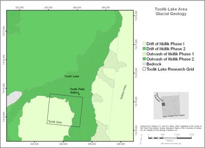
(from metadata) The map encloses a 20 km2 area surrounding Toolik Lake that stretches from the Dalton Highway on the east to Jade Mountain on the west. It includes the Toolik Field Station, the old Toolik Lake pipeline construction camp gravel pad and airstrip on the northeast side of the lake, and the primary terrestrial research areas on the south, west and east sides of the lake, as well as several smaller research lakes in the immediate vicinity of Toollik Lake. The area contains surfaces with irregular topography that were glaciated during the Late Pleistocene.
The glacial geology of the region affects a wide variety of landscape and ecosystem properties including topography, abundance of lakes, plant production, soil carbon, spectral reflectance, biodiversity, trace-gas fluxes and heat flux of the landscape. Glacial deposits within the Toolik Lake area are assigned to Itkillik I (late Pleistocene, about 120-150 kya) and Itkillik II (late Pleistocene, about 25-11.5 kya) glaciations of the central Brooks Range glacial sussession (correct spelling??).
 |
|
| The University of Alaska Fairbanks is an affirmative action/equal opportunity employer and educational institution. | |
|
Loading
| |
Last modified: October 26, 2012