Toolik Lake Grid Surficial Geology
- Toolik Grid
- Vegetation
- Elevation
- Landforms
- Releve Locations
- Glacial Geology
- Percent Water
- Surficial Geology
- Surficial Geomorphology
| Available data: | ||||
 |
 GE |
 Metadata |
 GIS data |
 GIS data |
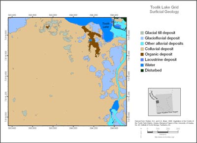
(from metadata) The Toolik Lake Grid map focuses on the south side of Toolik Lake. This area is one of the principal intensive research areas at the Toolik Lake Field Station. It includes many experimental research sites where long-term observations and experiments are being conducted, including the greenhouse and snow-fence experiments. The grid was constructed in 1989 to provide geographic referencing for experimental plots and to provide a sampling scheme for periodic measurements of snow, active layer and plant communities.
Surficial geology affects vegetation patterns and disturbance recovery rates. Surficial geology was grouped into the following classes for map display:
NOTE: The TL5C surficial geology metadata did not include a description of bedrock; is this a mistake or is there a reason for leaving bedrock out?
Surficial geology affects vegetation patterns and disturbance recovery rates. Surficial geology was grouped into the following classes for map display:
- Glacial till deposit: Glacial till in the region was deposited during the Sagavanirktok and Itkillik glaciations (mid and late Pleistocene). Till surfaces are generally rocky and gently undulating with blockfields, and nonsorted circles. Till on most surfaces has been covered by fine-grained colluvium that has been transported from upslope.
- Glaciofluvial deposit: Outwash deposited by meltwaters from the Pleistocene glaciers. Glaciofluvial deposits cover large areas marginal to many modern floodplains. Outwash deposits have irregular, rocky microrelief with a wide variety of landforms including kames, kame terraces, and flat terraces with high-centered polygons.
- Other alluvial deposits: Stream deposits occur on modern and ancient floodplains, watertracks, and alluvial fans.
- Colluvial deposit: Hillslope deposits whose origin is due primarily to downslope movement of material under the force of gravity, but often also in association with forces due to water movement. Colluvial materials often cover other deposits and bedrock.
- Bedrock: Includes all exposed bedrock and weathered bedrock deposits. Most bedrock is a mixture of sandstone and conglomerate (Kanayute Formation).
- Organic deposit: Organic deposits greater than 50 cm deep occur in colluvial basins and in some areas with wide watertracks.
- Lacustrine deposit: Lake sediments occur in association with drained glacial lakes such as Galbraith Lake and along the Sagavanirktok River, and a few much smaller drained glacial kettles and ponds.
- Eolian deposit: Windblown fine sand and silt associated with drained lakes and loess from rivers.
- Water: Includes lakes, ponds and rivers.
- Disturbed areas: Includes all anthropogenic disturbances, such as gravel pads, gravel mines, and airstrips.
 |
|
| The University of Alaska Fairbanks is an affirmative action/equal opportunity employer and educational institution. | |
|
Loading
| |
Last modified: January 17, 2012